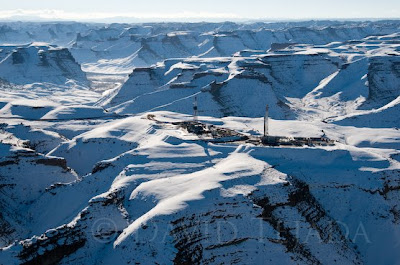
 Last month I was on assignment for an energy client of mine, I was sent to Utah to shoot some helicopter aerials of 2 drilling rigs. These rigs where drilling in the Greater Natural Buttes near Vernal, UT. drilling almost side by side.
My client thought that the close proximity of the two rigs as well as the natural beauty of the setting, would allow for some beauty images. It's unusual to see two larger rigs drilling so close to one another, I had never seen two rig of their size so close together before.
Erik and I drove out to Vernal from Denver, as a flight to Salt Lake and than driving 2 1/2 hours to Vernal would be about the same amount of time either way. Besides, I enjoy driving and the opportunity to shoot along the way is always inviting.
We spent the night in Vernal, awoke the next morning to meet up with our escort to drive out to the rigs. We went out to the rigs to get some ground shots as well as getting a fix location on my Tom Tom navigation devise for the helicopter pilot for the next days aerials. There are lots of rigs drilling in the Natural Buttes area and locating our rigs from the air would have proven difficult without the proper longitude & latitude coordinates.
Prior to arriving in Vernal for this assignment, I made arrangements with a helicopter service out of Park City, UT for our aerial photos. I make it a company policy that helicopter charges are bill directly to the client, these are expense I do not want to carry for my clients. The hourly rate on this helicopter runs about $900.00, not the type of expense I want to carry for 30 days.
On the day of the aerials, I received a phone call from the pilot in Park City, UT stating that he was fogged in and that he would be around 30 minutes late. The weather in Vernal was clear and cool, not a cloud in sight. Erik and I left the hotel, grabbed a couple of large coffees and headed to the FBO at the Vernal airport to wait for the helicopter.
The helicopter arrived about 40 minutes late, we loaded quickly and headed out to the rigs. I provide the pilot with the coordinates obtained the previous day at the rigs and he plugged them into his NAV system. We had about a 20 minute flight to the rigs, driving time the previous day took 2 1/2 hours due to the muddy & winding dirt roads.
As we left the ground and started heading south of Vernal it was clear and beautiful. As we gained altitude we could see low clouds (fog) hugging the ground further south of our location. As we continued flying, I was growing more concerned about the weather ahead. The pilot continually called out the distance to the rig and I keep trying to guesstimate if we where going to fly out of the foggy area below us. The fog was patchy and it was my hope that we would find our rigs in the clear. The photo at the top of the page indicates that we did.
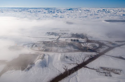
My client also had a processing plant they hoped to get aerials of while out shooting the rigs. This photo will give you a good idea of the type of fog issues we where dealing with while flying out to the rigs.
 Here is a short video from our shoot in Vernal. I hope you enjoy it. DT
